

Rain, gusty winds and mountain snow to carry through the week
A glimpse of sunlight, but an otherwise wet week
Those few days of dry weather with sunlight we were tracking have sadly vanished. Sunday will see breaks of sun, but will otherwise be rainy like the rest of this week!
SEATTLE - Grab the rain jacket and waterproof shoes! Heavy rain is sweeping through the lowlands today, and hefty mountain snow is expected, too. Strong winds in some areas could topple trees, tree limbs and patio furniture. High winds could also knock out power.
Gusts today could reach 40-50 mph for the coast and Northwest Interior. That's where a Wind Advisory is in effect until noon today. A High Wind Warning is in place until noon for Port Townsend, the San Juans and Camano and Whidbey Islands—for gusts potentially reaching 60 mph. After noon, the warning gets downgraded to another Wind Advisory. Gusts could blow to 50 mph from noon to 7 p.m. for the north islands and Port Townsend.
Elsewhere in Puget Sound, gusts 20-40 mph today will make temps feel quite chilly. I'm concerned that some gusts in Central and South Puget Sound could briefly reach 45-50 mph, but gusts under 40 mph will be more common for those areas.
Driving will be a mess today. Waterlogged roads could be slippery for drivers in the lower elevations. Over the mountain passes, strong winds and steady snow will make for really dangerous travel. A Winter Storm Warning is posted through 4 a.m. Sunday. An extra one to two feet of snow is possible! Gusts to 45 mph will lower visibility, too. Please check conditions with WSDOT before heading over the higher terrain!
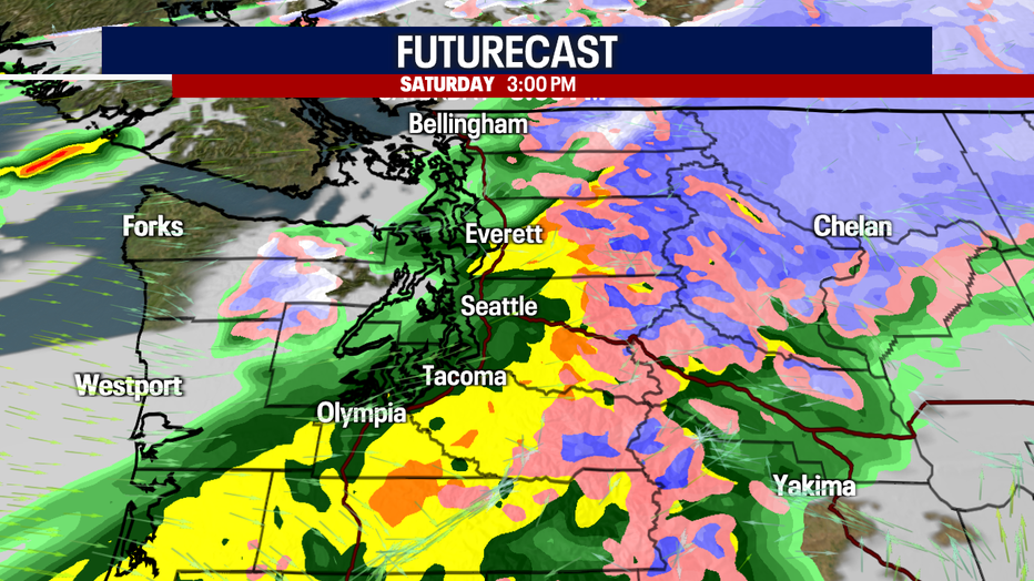
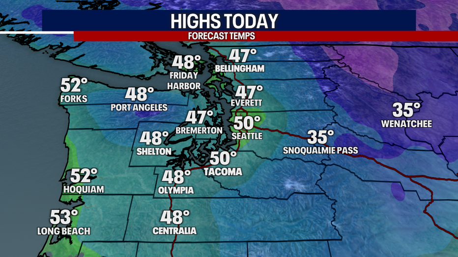
Highs later today will only reach the upper 40s to low 50s. We'll hit our high temps around 2 p.m. The heaviest, most widespread rain and strongest gusts will happen before 3 p.m. After that, a convergence zone could still trigger lowland rain and mountain snow in north King, Snohomish, Skagit and Whatcom Counties tonight.
We'll dry things out for most Sunday morning. Seattle sunshine fans, you'll love our forecast tomorrow. A few showers and chilly temps are on deck, but at least we'll enjoy some blue skies and sunshine.
Moderate mountain snow on Monday could snarl travel over the passes. Monday and Tuesday, there's even a chance for pops of snowflakes over the foothills. Little to no accumulation is expected below 1,500 feet.
Wednesday and Thursday, isolated to scattered showers are possible. There's still some uncertainty about what to expect.
Friday is Christmas Eve (I can't believe it!). Right now, looks like Mother Nature will serve up hefty mountain snow once again. Keeping in mind the extended forecast is highly subject to change—right now, forecast models are suggesting highs on either side of 40 degrees for Christmas Day in Seattle. There could be some showers, but there's uncertainty how low snow levels may be. One model is suggesting a few lowland snowflakes for Christmas Day, but I'm not buying that forecast quite yet. Stay tuned!

MORE FROM FOX 13 WEATHER:
DOWNLOAD: FOX 13 Weather and News Apps
WATCH: Forecast and Radar
READ: Closures and Delays
CHECK: Latest Weather Alerts and Live Traffic Map
INTERACT: Submit your Weather Photo
DAILY BRIEF: Sign Up For Our Newsletter
FOLLOW: Lisa Villegas, Erin Mayovsky, Brian MacMillan, Abby Acone and Scott Sistek
Watch FOX 13 Seattle for the latest news: