

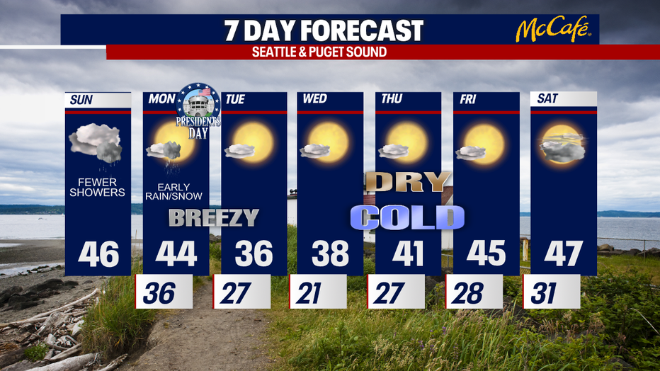
Lowland snow on Monday, with temps in the 20s later this week
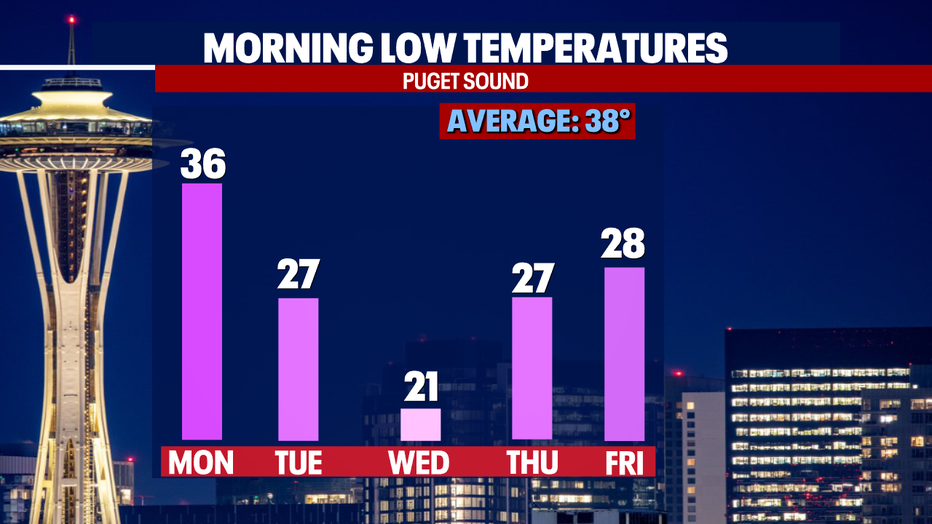
SEATTLE - A few snowflakes could fly in the lowlands late Sunday to early Monday! Later this week, overnight lows could plunge to the upper teens to low 20s in Puget Sound.
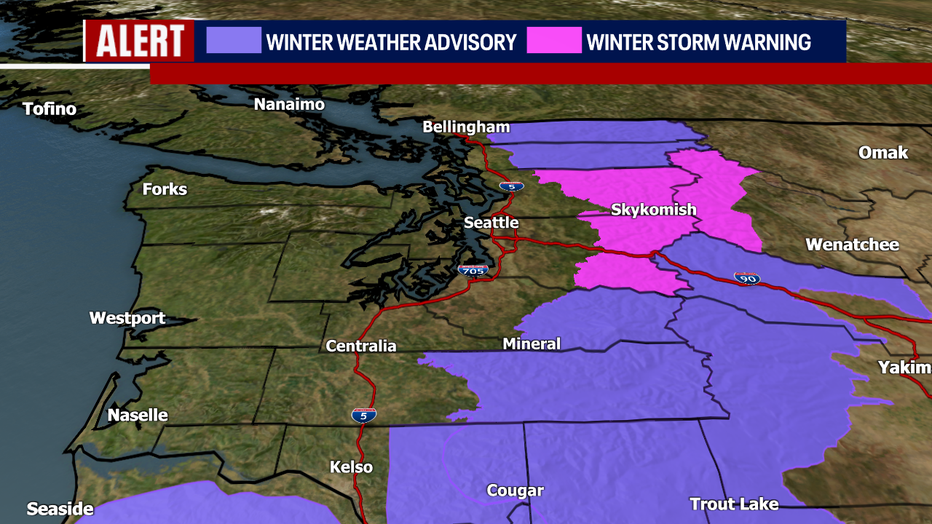
In the short-term, winter weather alerts continue for the Cascades until 4 p.m. Showers this afternoon won't be as widespread as what we saw overnight; however, there could still be bursts of heavy snow (most likely for either Stevens or Snoqualmie passes). Drive carefully and check WSDOT for conditions and any restrictions before you travel.
In the lower elevations today and Monday morning, a few convergence zones could bubble up. Where these "zones" happen (most likely in Pierce, King and Snohomish Counties), there could be cloudy skies and showers. I even can't rule out stray lightning strikes or pockets of small hail and graupel.
Still, there's a much better possibility for lightning over the South Sound and the Washington coast today – though showers there will be less widespread than in Central Puget Sound.
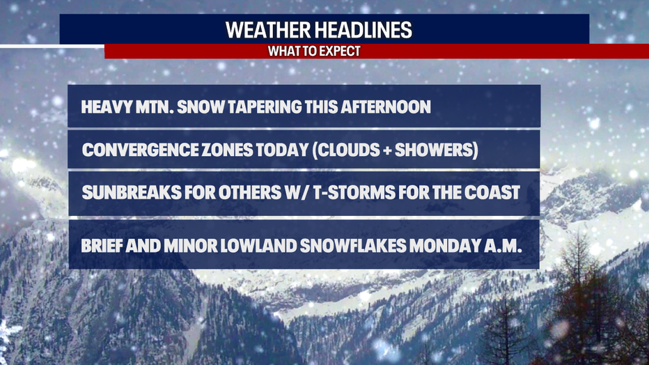
Any snow overnight Sunday to Monday probably wouldn't stick to the ground below 500 feet; even if there's a quick and light coating, it should melt fairly quickly. That's because temps for the most part will stay above-freezing in the lowlands.
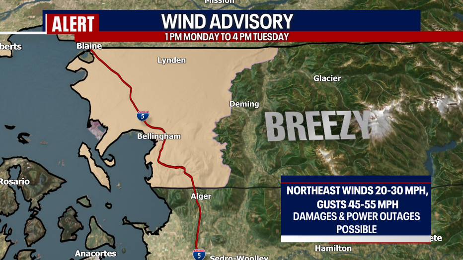
As temps drop this week, it'll be gusty in the North Sound. A Wind Advisory is in effect from 1 p.m. Monday to 4 p.m. Tuesday. Gusts of 45-55 mph could lead to minor damages and power outages. Keep the flashlight close by and make sure to keep your phones charged!
While temps plummet in a major way Tuesday and Wednesday, it should be mostly dry during that two-day stretch. Mostly sunny skies are on tap for the rest of this week. Temps will recover to the mid 40s next weekend.
Hope you catch FOX 13 tonight!
Take care,
Meteorologist Abby Acone
Don't hesitate to reach out to me anytime on social media: Twitter @abbyacone, Instagram @abbyaconewx, TikTok @abbyaconetv and Facebook (Meteorologist Abby Acone)
MORE FROM FOX 13 WEATHER:
DOWNLOAD: FOX 13 Weather and News Apps
WATCH: Forecast and Radar
READ: Closures and Delays
CHECK: Latest Weather Alerts and Live Traffic Map
INTERACT: Submit your Weather Photo
DAILY BRIEF: Sign Up For Our Newsletter
FOLLOW: Lisa Villegas, Erin Mayovsky, Brian MacMillan, Abby Acone and Scott Sistek