

FEMA's National Risk Index overlooks Washington's major disaster threat
FEMA's National Risk Index overlooks Washington's major disaster threat
It is a major fault line that will cause the biggest earthquake and ensuing tsunami our region has seen in centuries. When it hits, it is expected to be the largest disaster in United States history.
Seventy miles offshore, deep under the sea floor of the Pacific Ocean, a sleeping threat lies called the Cascadia Subduction Zone.
It is a major fault line that will cause the biggest earthquake and ensuing tsunami our region has seen in centuries. When it hits, it is expected to be the largest disaster in United States history.
Emergency managers on the Washington coast are pleading to the Federal Emergency Management Agency (FEMA) after an online risk index released by the agency fails to address the dangers.
It is an omission that could have catastrophic consequences.
It will only take about 15 minutes after the earthquake begins for a massive tsunami wave, 50 to 100 feet high in spots, to hit the Washington coast.
The water will cover beaches, boardwalks and waterfront property first. Then it'll hit schools, homes, and businesses inland. It will be a catastrophic wall of water taking out everything in its path.
Hannah Cleverly, the deputy director of Emergency Management in Grays Harbor County, is a part of a group of emergency managers in the state questioning FEMA's latest National Risk Index (NRI).
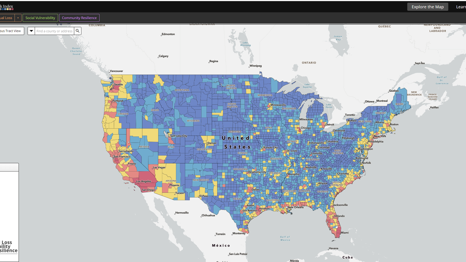
FEMA's National Risk Index visualizes natural hazard risk metrics based on 18 natural hazards, expected annual loss, social vulnerability and community resilience. (Screenshot of FEMA Risk Map)
The NRI map looks at every county in the United States, assigning risk ratings to threats like landslides, wildfires, and winter weather.
The problem? The risk of a tsunami disaster is a threat the NRI map seems to be ignoring. All of Washington’s coastal counties were assigned "relatively low" to "relatively moderate" tsunami risk, even though some coastal cities would be buried underwater.
"When there's only so much money, and who gets to make the final decision on who gets what, they're going to look at maps, and they're going to look at hazards and the risk index," Cleverly says.
According to Washington State’s Emergency Management officials, 50 to 80 vertical evacuation structures need to be built. The structures are designed with multiple stairwells leading to a reinforced rooftop deck and built high enough to stay above the water.
Currently, there are only two in Washington state, with a third one approved last year. As a tsunami approaches, these types of structures will be the only chance of survival for many on the coast. These structures cost millions. It’s more than the local governments can take on themselves. A recent bond measure failed in Grays Harbor County to fund vertical evacuation structures at schools in Ocean Shores.
This omission by FEMA’s NRI could have massive impacts on how coastal communities get the funding to build these structures.
"The risk is as high as you can get," says Oregon State University paleoseismologist Chris Goldfinger.
Goldfinger studies ancient earthquakes along the Cascadia and San Andreas faults. He contributes to an earthquake archive that goes back over 10,000 years.
"If I were king and if I were the head of FEMA, I would pull the report," Goldfinger said. "Just take it off the air right away and revise it … make it match what's known about the science."
But, FEMA says, that’s not a part of the plan.
In one of FEMA’s first interviews about the NRI, we spoke with Casey Zuzak, the lead manager of FEMA’s National Risk Index in Washington D.C.
"A lot of the data and information that goes into modeling hazard loss and hazard loss information is not consistently available across the country," Zuzak said.
The NRI’s data only goes back to 1800, which is 100 years after the last major Cascadia earthquake.
"We haven't seen a Cascadia event, since 1700, over 324 years, which makes it really challenging to understand what the actual impacts would look like along the coast today," Zuzak said.
Zuzak says the plan is to release an update at some point in the future, after working with national tsunami hazard mitigation partners. He would not give a specific timeline for this release.
"There are five federal employees just for reference," Zuzak said. "And the National Risk Index is not the only product and tool that we operate and maintain. We have several others within our portfolio that we manage."
To update the NRI, those five employees have to crunch decades’ worth of historical disaster data, and do it for every census tract in the United States, all 73,057 of them.
"You can't change things in a day. It takes time," Cleverly said. "Sometimes we are given the time, sometimes we're not given the time. And because we have scientists, and we have subject-matter experts that are telling us, ‘Hey, this can happen in the near future.’ Let's be prepared for it.
MORE ENVIRONMENTAL NEWS:
WA lawmakers pass bills including octopus farming ban, gun restrictions
Puyallup family raising funds to help loved ones who lost home in Japan's New Year's Day quake
Earth sets heat records for 9 straight months as February 2024 goes down as planet’s hottest
The Arctic Ocean could be ‘ice-free’ by 2030s
"If I was living in coastal Washington right now, I'd be beating the bushes to try to get towns and counties and the state prepared," Goldfinger said. "Because we're not even close at this point."