

Déjà vu: Temperatures in the Pacific Northwest soar on year anniversary of record-breaking heat wave
Heatwave runs through Monday before calming down this week
FOX 13 Forecaster Erin Mayovsky has the details.
The summer swelter is underway in the Pacific Northwest amid a heat wave occurring on the anniversary of last year's record-breaking heat wave.
According to FOX Weather, parts of Oregon and Washington set new records last year, with high temperatures well above 100 degrees on June 26 and 27. This week, temperatures are hot but not nearly as scorching as last summer.
On June 27, 2021, Portland hit 112 degrees and the following day reached 116, a record for the city. Eugene, Salem, Astoria and McMinnville also set all-time records on June 27.
Heat safety tips for summer
Prevent heat stroke and exhaustion by staying hydrated, avoiding strenuous activity and wearing light clothing.
RELATED: Seattle weather: Sizzling heat in Western Washington
On Sunday, the NWS in Seattle/Tacoma tweeted that Seattle-Tacoma International Airport reached over 90 degrees for two years in a row. Last year on June 26, the high was 102 degrees.
Temperatures on Monday will be between 10 and 30 degrees higher than average, but there is good news for the Pacific Northwest with a cool down coming.
The heat will peak Monday with highs forecast to reach into the 90s and 100s outside the coast and mountains, still nowhere near the 110+ temperatures of last summer's heatwave.
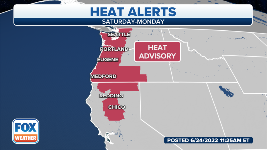
Heat advisories have been issued for 25 million people in parts of California, Oregon, Washington and Idaho.
RELATED: Minutes matter: What you should do if you see a child locked in a hot car
National Weather Service offices in Portland and Seattle have issued a Heat Advisory for parts of northeast Oregon and southern parts of the state, including Medford down past the California state line. In Washington, the advisory extends across parts of northwest and west-central Washington.
Major cities, including Portland, and Oregon City in Oregon, are part of the advisory. The Heat Advisory extends across Seattle, Tacoma and Olympia, Toledo and Forks in Washington.
By mid-week, the above-average temperatures will shift away from the Northwest and back to the Plains by Wednesday.
According to the NWS Seattle, there is one more hot day up and down the Interstate 5 corridor before cool marine air pushes on Monday night into Tuesday.
A surge of cool air moving along the Oregon coast will bring relief along the coast later Monday but won't drop temperatures inland until Tuesday.
The Portland metro area will be the last to cool down Monday evening, according to the NWS Portland. Temperatures will be in the mid-70s to the lower 80s near into the overnight hours.
This slow cool down is partly due to urban heating effects like large areas of asphalt and concrete. Urban areas tend to retain heat longer than green open spaces.