

Skokomish River Valley submerged by flooding
MASON COUNTY, Wash. - An atmospheric river brought extra rain to Mason County on Tuesday, causing flooding along the Skokomish River.
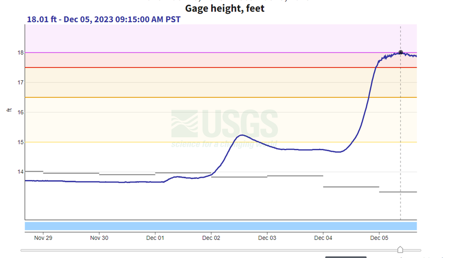
Preliminary information showed that the main stem of the river near Potlatch crested around 18-feet on Tuesday, just shy of the 18.2-feet record set in 2007.
(U.S. Geological Survey)
"I made it through, but I wouldn’t say a car should go through that," said Trina Crowe, who drove over water-covered roads near Skokomish.
A number of roads were blocked by cones, and road signs. Locals warn that you’re best to turn around and find an alternative route. As first responders often warn, "turn around don’t drown," citing that water can often be deeper than it appears.
"This is a significant event flood-wise, for sure," said Eric Rader, a hydrologist with a U.S. Geological Survey (USGS) team.
Rader and three team members were out near the Skokomish River to take real-time data, to compare to fixed-site rain gauges that take snapshots every 15 minutes. That data allows them to get additional information beyond elevation, and to fine-tune equipment so they better understand the threat of flooding as things change over time.
"We strive our best to give the best data we can because we know so many life and property decisions are made based on our data," said Rader. "We take it seriously."
RELATED: Rising Stillaguamish River hits flooding record in Arlington
The Skokomish, and adjacent creeks that flooded Tuesday, are part of a program that USGS is working on with the Skokomish Tribe according to Rader. He said that new data will help the tribe, and locals, better understand how the river floods as the river takes on sediments that have washed downstream from higher elevations in recent years.
Meanwhile, locals say the flooding is good reason to avoid being out.
"If you don’t have to work, I’d stay home," said Crowe. "I’ve got to work, so I’m in it."