

Winter storm warning to impact over 3 million people in western Washington
SEATTLE -- More than 3 million people will be under a winter storm warning starting at noon Friday.
Snow flurries started early Friday morning, with the warning kicking in at noon as heavier, steady snow is expected to last into the afternoon and overnight through Saturday.
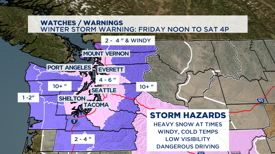
Highs climb into the mid 30s at best-- but that still is cold enough for sticking snow with an already frozen ground in a lot of places. This will lead to low visibility and some dangerous driving conditions.
At 10 p.m., we've got a High Wind Warning for areas up north. Gusts between 50-60 mph can make it dangerously cold and lead to blowing snow.
For the waters in that area it's a Gale Force Wind Warning, so don't be too surprised if the choppy waters cause ferry delays and maybe some cancellations too between tonight and until midnight on Sunday.
There are more than 100 flight cancellations at Sea-Tac Airport due to weather, and more than a dozen King County Metro bus routes are canceled.
Sunday looks dry, but we'll still be locked in the freezer.
Monday starts out dry, but forecast models are hinting at round three of possible snow.
Snowfall estimates:
Here's a look at viewer-submitted photos from around western Washington:
Q13 Weather Resources