

Snow blankets the Puget Sound region
SEATTLE -- Several inches of snow fell overnight in some parts of the Puget Sound Region, bringing "mayhem" to many roads and prompting road and school closures across the metro.
A Winter Storm Warning for the East Puget Sound Lowlands and Everett area and the Winter Weather Advisory for Seattle-Tacoma metro have been extended until 1 p.m. Monday.
Many schools, government offices and businesses are closed. Click here for school closures. Click here to see the latest traffic conditions.
Power outages were reported by Seattle City Light and Puget Sound Energy. About 15,000 were without power as of 3:30 p.m. Monday. Click here and here for the latest outage numbers.
Q13 Meteorologist MJ McDermott says the snow that fell overnight is frozen on the ground, and it continues to snow in the Central Sound with snow showers almost everywhere this morning. This afternoon we will dry up from the north to the south and see some sun before the sun goes down.
Winds are whipping, with gusts in the 50+ mph range in Whatcom County. It’s cold this morning, with temps in the 20s for most, but it FEELS LIKE single digits or teens due to wind chill factor. Bellingham’s wind chill factor was -6 degrees at 6 a.m.
This afternoon’s highs will be around freezing, so not much melting happens. Roads will be icy and dangerous ALL DAY.
Tonight will be getting clear and very cold, with lows in the teens and 20s, but it’ll feel colder with the wind chill factor.
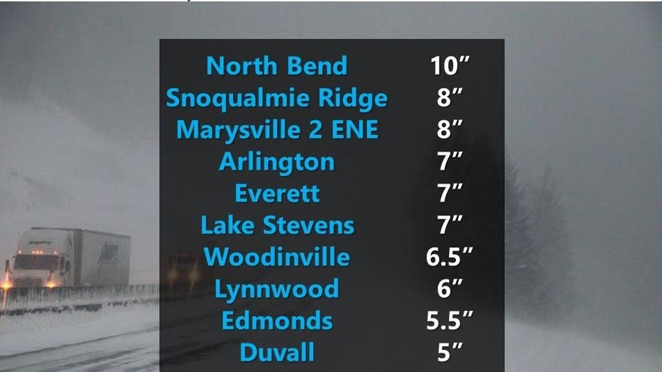
Photo courtesy National Weather Service
Thursday through the weekend, there’s a chance of rain/snow showers. So, stay tuned!
In Seattle, it was 28 degrees with a wind chill of 21. At SeaTac Airport, the wind chill made it feel like 14 degrees. Several flights were canceled, and dozens more were delayed. Click here for the latest on flights out of Sea-Tac Airport.