

Climatologists keep an eye on snowpack during warm January
SEATTLE -- Ask any hardcore skier about the season so far, and you might get a simple response.
"Meh."
There have been a handful of powder days in the Pacific Northwest. But for the most part, they've been few and far between.
And the state's snowfall totals seem to bare this out. Washington sits below normal in terms of annual snowpack through Jan. 21.
It's not the worst the state has seen. Most areas sit somewhere between 70 percent and 90 percent of average snowfall.
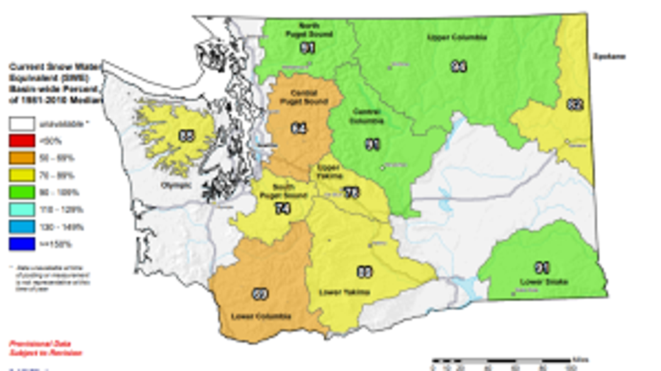
Washington SNOTEL snowpack report.
Washington State Climatologist Nick Bond says the winter - and this month - have been on the "warm side." It's early yet, and snowfall levels can certainly reach normal, Bond said.
But the die begins to be cast by mid-February.
"It doesn't look like a record so far, but it's definitely been one of the warmer years we've had," Bond said.
The state keeps a close eye on snowfall totals, because they greatly impact water levels later in the summer. Since most of the state's water comes from snowfall, a robust snowpack is important. The state's agriculture - from apples to wine - depend on rivers and irrigation fed by snowfall.
"There could be some minor hardships in the summer coming ahead," Bond said.
Though we're seeing less snowfall than normal, the state severe drought conditions aren't on the immediate horizon.
Farmers in Washington lost more than $300 million due to one of the worst droughts in state history in 2015. The state is not anywhere near those conditions, but it's important to keep an eye to the snowpack, Bond says.
"Mother nature holds the cards and it seems like sometimes she just doesn't play fair," Bond said.
The snow level should get a boost Tuesday night. Mountain snowfall is expected through Wednesday morning, with up to 9 inches for the passes.
For the latest forecast, head to our Q13 News weather page