

It's the calm before the next several storms: Rain, wind and mountain snow
It's the calm before the next two or three storms.
Q13 News Meteorologist Tim Joyce says to expect a chilly morning with some on/off showers out there. Cold enough for some of those heavy showers to have some snow flakes mixed in. A warm hooded jacket will help you take on your Friday. An umbrella would likely be turned inside out from the breezy south winds. We'll see those showers become steady snow in the mountains.
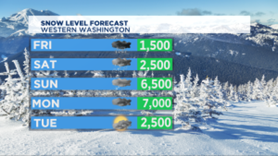
We've got a WINTER STORM WARNING for areas near Mount Rainier, including Paradise. 6-9 inches of fresh snow expected today with lesser amounts for the I-90 and US 2 passes where there's a WINTER WEATHER ADVISORY. All of those passes will start getting rain this weekend as Mother Nature points the firehose onto the Pacific Northwest.
A lot of rain at times and wind too. What makes me optimistic about this weekend is the timing. The periods of heaviest rain look to be in the overnight hours.
The first of several soggy weather system rolls in Friday with heavy rain and wind. Saturday during the day could end up being breezy with scattered showers. The next moves in Saturday night, then again Sunday night into Monday.
The weekend's rapid warming will send our temps soaring into the mid 50s and near 60 in SW Washington and Portland area. Warmer temps mean snow levels also go up quickly, that snow melt will send our rivers and creeks running fast and high. The landslide risk will go up for the lowlands and avalanche issues in the high mountain back country too.
A return to more January chilly showers as we get into Tuesday and the rest of next week. Seasonal temps for the lowlands in the upper 40s. Snow levels falling back to below the passes too.